Submerged Worlds
By Kiki Kuijjer
This work turns seafloor data from three regions of the world into 3D-printed seascapes, revealing hidden islands, towering seamounts, and deep ocean troughs. Some seafloor features were once above water, others have never been directly encountered, and many are ecologically rich or contested for their resources.By making these submerged worlds tangible, the prints invite curiosity and reflection on exploration, knowledge, and the limits of what we understand about our planet. Between scientific model and artistic object, they offer a hands-on encounter with environments that are still largely unseen, underexplored, and full of secrets waiting to be discovered.
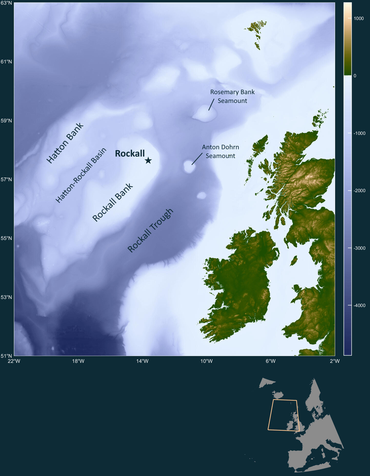
Rockall
Far beyond the coasts of Ireland and Scotland, the Rockall region rises from the deep Atlantic. Beneath the surface lies a vast underwater landscape of banks, seamounts, ridges, and troughs formed over millions of years. The small rocky islet of Rockall is only the most visible part of a much larger geological structure extending across the ocean floor.These waters support cold-water coral reefs, deep-sea ecosystems, migratory species, and important fisheries. At the same time, the region has been the subject of overlapping claims and competing interests relating to fishing, seabed resources, and maritime jurisdiction. The boundaries drawn on maps do not always align with the interconnected nature of ocean ecosystems.The Rockall region illustrates why international cooperation is increasingly important for protecting marine life. Recent agreements such as the Biodiversity Beyond National Jurisdiction (BBNJ) Treaty aim to strengthen conservation in areas beyond national borders, reflecting growing recognition of the ocean as a connected global system.
👋 Feel free to touch the 3D print. Touch allows the shape of the seafloor to be experienced in a new way, revealing details that are not always apparent from 2D maps and images alone.
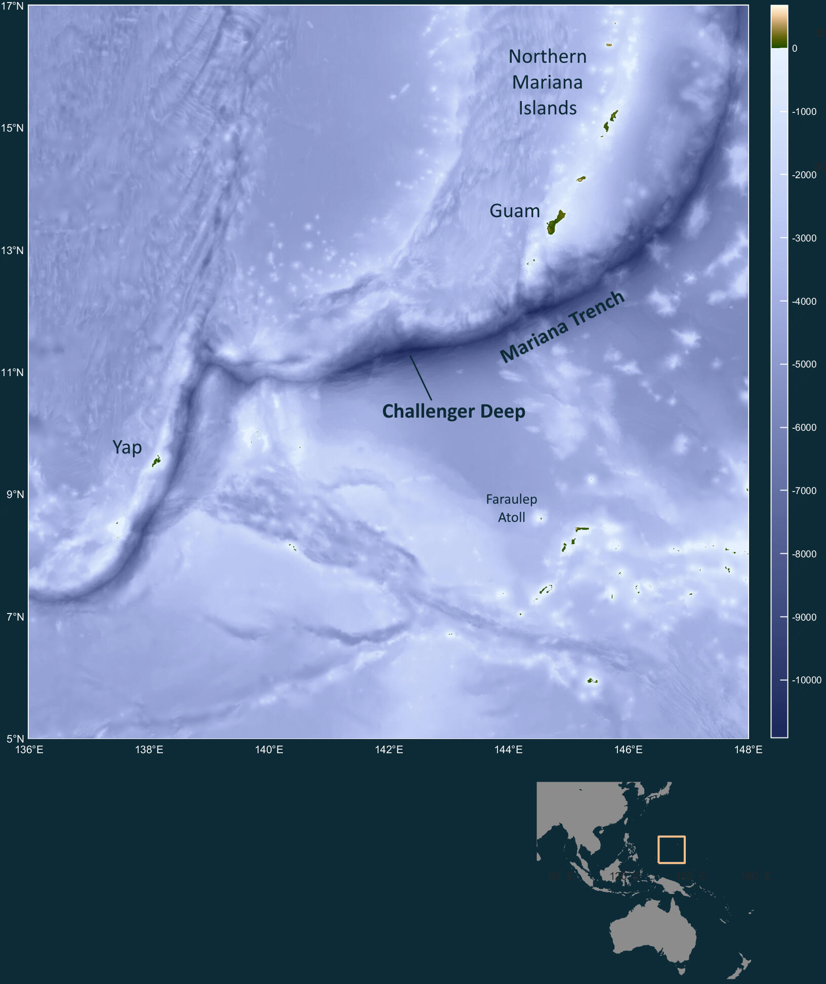
Challenger Deep
Located within the Mariana Trench in the western Pacific Ocean, Challenger Deep is the deepest known point on Earth. Reaching nearly 11 kilometres below global mean sea level, it lies in a region where one tectonic plate is slowly being forced beneath another, creating a vast ocean trench and the volcanic Mariana Island Arc over millions of years. The islands are the highest points of a much larger mountain chain, most of which remains hidden beneath the ocean surface.Despite its fame, Challenger Deep remains one of the least explored places on the planet. The immense pressure, complete darkness, and remote location make exploration difficult, and only a small number of crewed and robotic missions have reached its deepest depths.Research at Challenger Deep continues to reveal new forms of life and the remarkable adaptations needed to survive under extreme pressure. At the same time, traces of human-made pollution found in the trench demonstrate how even the most remote parts of the ocean remain connected to the wider world.
👋 Feel free to touch the 3D print. Touch allows the shape of the seafloor to be experienced in a new way, revealing details that are not always apparent from 2D maps and images alone.

Bonaparte Gulf
The Bonaparte Gulf, between northern Australia and Timor, is a region shaped by changing sea levels. Around 60,000 years ago, when the first people arrived in Sahul, global sea level was significantly lower than it is today and the coastline lay far beyond its present position.The brown areas shown in this print represent land that would have been exposed when mean sea level was approximately 95 metres lower than today. Under these lower sea-level conditions, these landscapes formed part of Sahul, the continent that connected Australia, New Guinea, and Tasmania. Today, much of this former land lies beneath the waters of the modern gulf.This now-submerged landscape formed part of the world encountered by the first people to reach Sahul. Changing coastlines and marine pathways, strong tidal currents, and shifting marine environments would have influenced how people experienced and moved through this region. Today, the seafloor offers a rare window into landscapes and environments that have long since disappeared beneath the sea.
👋 Feel free to touch the 3D print. Touch allows the shape of the seafloor to be experienced in a new way, revealing details that are not always apparent from 2D maps and images alone.
About
This work transforms digital seafloor data into physical landscapes that can be seen and touched. The 3D models were created using bathymetric data from the General Bathymetric Chart of the Oceans (GEBCO) and processed in MATLAB before being 3D printed. The accompanying 2D maps use scientific colour maps developed by Fabio Crameri.The prints were produced in PLA, a plant-based bioplastic, using a Bambu Lab 3D printer at Digital Scholarship, University of Southampton.The vertical scale on the prints has been exaggerated equally across all three prints to make subtle seafloor features visible and allow comparisons between regions.To learn more about my work and projects, visit my website.